About Us Our Services Our Products Contact Us
Geospatial Services Terminal & Transmission Terrestrial & Undersea

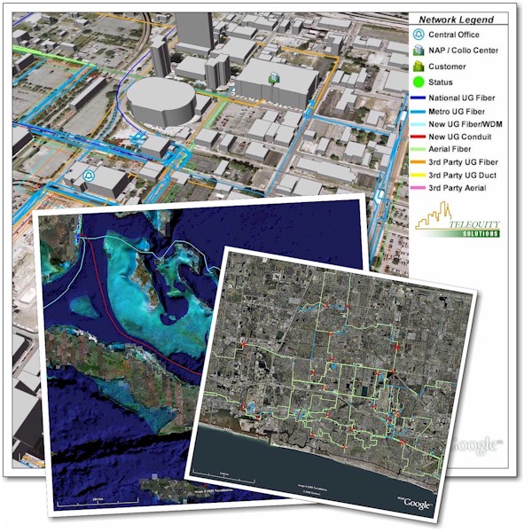
In order to plan, implement, and utilize telecommunications assets more efficiently, Telequity has pioneered the development and use of geospatial tools for AT&T and other customers.

Using our tools and resources, we have been able to present our customers with tremendous cost-saving opportunities during the planning and implementation of their network projects, helping them to save tens of millions of dollars without compromising on diversity, reliability, or security.

Especially effective for complex, geographically diverse network projects or assets, our geospatial services allows service providers to visualize existing network assets and plans, enabling:

More effective planning for business case approvals
More cost-effective project management and powerful visual status reporting
Rapid identification of cost-saving or revenue-generating opportunities
Better operational performance from fewer resources managing more assets
Faster & better decisions from actual network inventories or plans
Cost-effective network planning for mergers, migrations, and growth
Recovery planning for emergencies or disasters
Centralized asset record-keeping & management for geographically diverse or even global networks
Information management for continuous improvement of network asset details and accuracy
Asset-based business case development, desktop engineering studies, and presentations

For more information, please download our Geospatial Solutions & Services brochure (PDF* document).

*The free version of Adobe Reader software can be used to view and print PDF documents. Click on the Adobe Reader image to the left in order to download the latest version of the Adobe Reader software to your PC. Adobe Reader is a registered trademark of Adobe Systems Incorporated.


Copyright © 2024 Telequity Group Services, Inc., All Rights Reserved.
Use of this Web site subject to Legal Notices
Send Comments using Contact Us.